
автордың кітабын онлайн тегін оқу The Sperry Gyro-Compass
The Sperry Gyro-Compass, by The Sperry Gyroscope Co.
Copyright, 1920
THE SPERRY GYROSCOPE COMPANY
BROOKLYN, N. Y., U. S. A.
DESIGNED, ENGRAVED
AND PRINTED BY

ROBERT L. STILLSON
COMPANY NEW YORK

THE SPERRY GYROSCOPE CO.
MAIN OFFICE AND FACTORY
MANHATTAN BRIDGE PLAZA.
BROOKLYN, N.Y.
THE SPERRY GYROSCOPE COMPANY
Boston, Mass.
60 VIRGINIA STREET
Great Lakes District
828 GUARDIAN BUILDING
Cleveland, Ohio
San Francisco, Cal.
52 DAVIS STREET
Main European Office: THE SPERRY GYROSCOPE COMPANY, Ltd., 15 Victoria Street, London, S. W. 1
—REPRESENTATIVES—
France
Holland
Norway
COMTE A. DeCHAMBURE
37, Rue Bergere
Paris
TECHNISCH BUREAU VAN LEENT
Nassaukade 17
Ryswyk
OTTO PLATOU
Skovveien 39
Christiania
Italy
Japan
GEORGES BREITTMAYER
20, Rue Taitbout
Paris
F. P. CAMPERIO
Via Bagutta 24
Milan
MITSUI & CO., LTD.
Tokyo
Sweden
F. J. DELVES
20, Rue Taitbout
Paris
GRAHAM BROS.
Stockholm
MITSUBISHI ZOSEN KAISHA, LTD.
Tokyo
(For Ship Stabilizer)
Spain
Denmark
Chili, Peru & Bolivia
F. WEYDMANN
Victoria 2
Madrid
C. KNUDSEN
11 Kobmagagade
Copenhagen
WESSEL DUVAL & CO.
25 Broad Street
New York

THE
SPERRY GYROSCOPE
COMPANY
Manufacturers of
GYRO-COMPASSES
GYRO SHIP STABILIZERS
GUN-FIRE CONTROL APPARATUS
NAVIGATIONAL INSTRUMENTS
NAVAL AND COMMERCIAL SEARCHLIGHTS
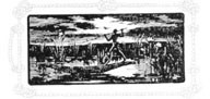
The ancient Egyptians built boats of rushes.
Putting the Earth to Work
HEN the earth was thrown off from the sun and commenced rotating about its own axis, there was developed a force generated by the earth’s rotation. For countless centuries this force has been at work, but no one has ever been able to harness it to serve the purposes of man. But now, through the efforts of Foucault, Hopkins, Sperry, and other noted scientists, this force has been put to work. It serves to direct a thousand ships in their courses.
Of course, this is not the only force which has been used to guide ships. Since 1297 A.D. mariners have used magnetic attraction as the force by which to guide their vessels. For centuries seafaring men sailed only in wooden ships, and were therefore satisfied with the magnetic compass. Then came steam and steel. Navigation then instead of being a hit or miss game of chance became the exact art of directing a ship by the shortest possible course in the quickest possible time.
Now that ships cost millions of dollars to build and thousands of dollars per day to operate, time has become the most essential element in navigation. The development of ships from the sailing vessel to the ocean greyhound has been one of the marvels of modern times. But the development of the magnetic compass has not kept pace with the development of the ships which rely upon it. Many of the great trans-Atlantic liners are guided by practically the same type of compass as that which Columbus used on the Santa Maria. The compass on the wooden Santa Maria pointed to magnetic north with a fair degree of accuracy, but the compass on the steel greyhounds must contend with many distractions.
For years magnetic compass designers spent their efforts to produce compensating devices that would annul the effects of all external influences, so that the magnetic compass would be free to indicate only the direction of the earth’s magnetic lines. Very little has been done to improve the compass itself—it still depends upon the attraction of the Magnetic North Pole. The Sperry Gyro-Compass differs in principle from any other compass. It is not magnetic. It derives its directive force, not from magnetic attraction, but from the earth’s rotation.
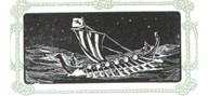
The Vikings crossed the Atlantic in open ships.
There is certainly a crying need for this new type of compass. A ship now-a-days costs millions of dollars and carries cargoes usually equal in value to that of the ship. It has been estimated that inaccuracies in navigation attending the use of the magnetic compass cause a yearly loss of ships to the value of $70,000,000. No estimate can possibly be made on the value of lives lost on these ships.
Millions of dollars are spent each year on charts, lighthouses, buoys, geodetic and hydrographic surveys, and on compilation of notices to mariners. Notwithstanding all of these, ships must ultimately depend upon their compasses for their safety and efficiency of navigation.
Inaccuracies in navigation can be eliminated by the use of a reliable compass. The Sperry Gyro-Compass puts the earth to work. It utilizes a force which is as unvarying as the law of gravity, a force that cannot be interfered with by any other influence.
How the Earth’s Rotation Is Utilized
Any wheel rotating at a high speed about its own axis, and free to place itself in any plane, is called a Gyroscope. The Gyroscope is the instrument which utilizes the earth’s rotation as a force to direct the course of ships.
Suppose you were to place such a small wheel supported by its axis upon a larger wheel which also is revolving. The rotation of the larger wheel would so influence the smaller wheel that its axis would point in the same direction as the axis of the larger wheel. Why this is the case does not concern us here. Let it suffice that the larger wheel will cause the smaller wheel to behave in this manner. This is in accordance with a natural law. This law operates as unfailingly as the law which causes an unsupported body to fall to the ground.
Suppose the larger wheel happens to be the earth, which in reality is a revolving wheel. Suppose further, the small wheel is a Sperry Gyro-Compass. In accordance with this natural law just outlined the smaller wheel, or Gyro-Compass, will point its axis in the same direction as the axis of the earth, or, in other words, to the true or geographical North Pole. This explanation of the principle of gyroscopic motion is necessarily crude. The principle itself has been established beyond any reasonable doubt. It can be proved by mathematics to the satisfaction of the most exacting scientist and has been demonstrated, throughout the navies of the world, to practical seamen.
The final result is that we have a principle which enables us to construct an instrument which will place itself in the true geographic north and south meridian, and that it responds to no influence or impulse other than the earth’s unvarying rotation.
Galley-slaves drove the Triremes of ancient Rome.
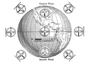
FIGURE 1.
The Earth Surrounded By Rotating Wheels As It Appears To An Imaginary Observer Looking At It From The Side.
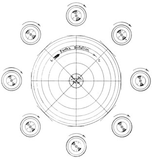
FIGURE 2.
The Earth Surrounded By Rotating Wheels As It Appears To An Imaginary Observer Looking Directly At The South Pole
A War-ship, “when knighthood was in flower”.
How a Compass is Used

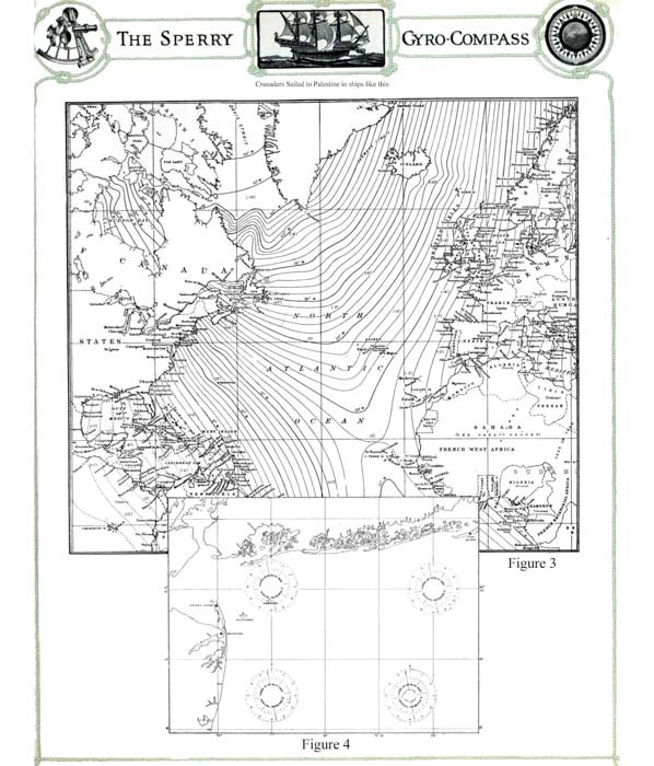
HE purpose of a compass is to indicate direction. The relative position of the North Pole to any point on the earth’s surface is called North. We figure all direction from this conception. This geographical North Pole is called the True North. About 800 miles from this True North Pole is a spot which has a strange magnetic attraction. The needle of the magnetic compass, if undisturbed by local influences, points to this spot, and not to the True North Pole. This spot is called the Magnetic North Pole. This mysterious attractive spot is not stationary. It moves about from year to year within a wide circle.
Inasmuch as the navigator must refer to True North, he must determine the angle or variation between True North and Magnetic North as indicated by his magnetic compass. This determination is made comparatively easy by using charts which express in degrees the difference between Magnetic North and True North for any point on the earth’s surface.
Such a chart is shown in Figure 3. Also on each chart used by a navigator for a particular locality there is marked a compass rose in which is recorded the variation for that exact spot as of a certain date, and in addition the rate at which the variation changes annually, Figure 4.
Navigation along a coast line where sights can be taken on buoys or lighthouses is simple, and is termed “piloting.” This, of course, can be done without the aid of a compass.
Upon getting to open sea the mariner checks his position in a similar manner, by observing the position of his ship in relation to the position of the sun, moon or stars. Between observations the position of a ship is determined by “dead reckoning.” The distance it has traveled from the last known position is measured by the ship’s log and the direction is indicated by the compass. Very often for days at a time, owing to weather conditions, it is impossible to get an observation or sight on a celestial body. During this run the navigator is dependent entirely upon the compass. The slightest error in the compass, due to variation or deviation, in such circumstances will cause the ship to be miles out of its course, and the actual position will be far from the calculated position.